Thursday, July 20, 2017

Spider on Steroids (SOS)

Sat July 15 I ran a route called Spider on Steroids in 20 hours. The route is ~50 miles long and has ~12,500 feet of elevation gain traveling over six mountain passes. Info for the route can be found here

https://www.facebook.com/notes/ultrapedestrian-wilderness-challenge/2017-upwc-list-of-routes/621583058029564/

I used topo map I used was Green trails Holden was no 113

River crossing at Little Giant trailhead.


This photo is just downriver from where I crossed. From the trailhead walked down to the river and bushwacked up stream to a gravel bar crossing there. The water was knee deep until one part where it came up to private parts for 10 ft until it went back to knee deep. I then bushwacked back downstream to the trail.

River to Little Giant pass.

Staying on the trail took careful looking in the beginning until I started up the hill. There was some blowdown  on the trail. I as able to work around everything. I think I am the first person to travel up this trail this season. I saw and will continue to follow animal track for quite awhile.


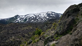
View as I travel up the hill.


Trail leads to snow patch in center of photo. I was able to work around it and was at Little Giant pass.


Warning post from last year's fire at Little Giant pass.

Little Giant pass to head of Napeequa valley. 

I keep a sharp eye on the gps track as following the trail off the pass was questionable at times. I think this is more animal track than people trail.


Valley I am traveling up.


The trail will vary between this and decent trail. For sections like this, your feet are on trail and the brush is brushing against your chest. My lower legs took a beating in places like this.


Nice waterfall in the valley.

Head of valley to High Pass

The climb up from the valley has a trail but is takes contraction to stay on it. It fades in and out at times. I think more animals travel on it than people. It is quite steep. Once you reach the top of the trail you will be in a hanging valley.


This is the view you will have looking up the valley you will be traveling. I was on snow for most of this. There were small patches of bare ground that I would see evidence of people travel.


Lake below point just before I reach High pass.


High pass in distance on left. Yes I am traveling across more snow. I am glad I had my ice axe.

High pass to Suiattle pass.


I am glad I had my ice axe for the small patches of snow I had to cross in the photo. Once I was done with the snow I had great trail to run on. It was nice to start making good time on good trails.


A left at Buck creek pass and more nice cruising to the PCT.


Buck mtn I think.

The PCT was a dream. It was so nice to travel on this well groomed trail.

Suiattle pass to Spider gap. 


This photo shows Cloudy pass in distance. I am glad for my ice axe crossing these little snow patches.


Nice valley to somewhere.


I am excited to see this view. Lyman lake and Spider gap in the distance. I have enough light to make it over the gap. Trail down to lake, around and to base of gap is a easy go. I saw many people camping and hiking around here.


Looking back on Lyman lakes to where I had come from.


Spider gap closer view now as I am almost there. I was able to travel on some rock and snow as I passed over the gap.

Spider gap to Little Giant trailhead. 

I was on snow half sliding my way down the snow field to dry ground.


View down valley I am traveling. The trail down this section was a little rough until I got  the valley floor. Once there I was on very good trail I could make good time on. I crossed through many streams on my way to Phelps creek trailhead. The road section was a bit long but I was glad that I did it at night as there was no vehicle traffic. 

This was a great trip and would recommend people with a sense of adventure to give it a go. Thank you Ras for posting it to UPWC. Thank you Heather for your slide show on it to entice me into running it. 


Sunday, July 9, 2017

Loowit Trail, Mt Saint Helens

On Friday evening July 7 I ran/walked around Mt Saint Helens on the Loowit trail. The trail is ~32 miles long with 9700 ft of elevation gain. It took me a little under 14 hours to complete this route.

Thursday evening I had all my gear ready for my adventure of cernavagating Mt Saint Helens on the Loowit trail. This is one of the Ultra Pedrestration Wilderness Challenges I am working my way through this list. Friday was slow at work and I thought, maybe I can leave early and start tonight. Well, Friday afternoon, my boss asked me if I wanted to leave early to take off on my trip. It was slow at work, sure I said if these few jobs can wait till Monday. So off I went heading south to June lake trailhead.

3:45pm and I am off on my adventure. June Lake trailhead is the closest point to the Loowit trail.

Once I hit the Loowit trail I turned left for a clockwise route around the mountain. I ran Bigfoot 200 last  year and that route covered some the the trails I would be traveling on. I also wanted to follow the sun for most daylight for moving. 

Trail conditions were a combination of snow in the trees and gullies I would cross many of. The PNW had a large snowfall this winter. The snow is holding on longer than usual this year. I had an ice axe and crampons on my pack that never left. There were many trees down on the trail that I easily worked around, over or under. There were a few patches of overgrown trail to work through. 

I had a wrist gps unit on that really came in handy to help keep me on the trail. With patches of snow here and there playing hide and seek with the trail. Traveling at night, being able to look down at my wrist to make sure I was where I wanted to be is is very reassuring. 


The first part of the trail is a combination of trail and rock hopping for a few miles. I meet many people headed back to their car from a day hike, coming down from the summit and others hiking around the Loowit trail. Living here in the PNW popular outdoor environment is seldom a solitary experience.  Once it got closer to night fall I would be alone till first light of morning. 


Things are going well as I travel along the trail. The drop down Crescent ridge was impressive as I lost a lot of elevation. I would cross the Toutle river (wet feet) next and head into the sand hill switchbacks as I call them. This section is a set of switchbacks that goes up a side hill of firm sand. I am guessing animal tracks set the trail each spring. I would see evidence of animal tracks the entire length of this trail. 


The sun had set now and it was getting dark as I got to the got to the top of this hill. The full moon is rising to light the way for me. A cloud is also rolling through that would settle in the valley. For now this cloud is getting my glasses wet making me clean them too often so I can see. There is a cool breeze rolling through with this cloud. It was time to add a lot more clothes as I was on a the blast zone plain. After a while the cloud would settle below me and the wind will calm down allowing me to peal off a few layers. My first headlamp had dead batteries (dumb move Jeff), second one was good. I had an extra set of batteries in my pack just in case. 

I enjoyed crossing the blast zone in the dark. The full moon lit up the area in a dull light allowing me to see everything. I still needed my headlamp to see detail for my foot placements. This was a magical experance to travel around part of this mountain in this dull light. I loved the reflection of the moonlight off the creeks and rivers I crossed. I wished I could have captured this on my smartphone camera. 

At the end of the blast zone is windy pass. Before climbing up windy pass I saw reflected something in front of me. I took a couple seconds to realize this was reflective strips off someone's tent, sorry for the lightbeam. Up and over Windy pass I go and down the other side. Coming down the other side the trail is not quite as good as the up. I saw more reflective stips off someone's tent and reacted quicker this time. 

I was on quite nice trail now and could get some running miles in till I got to the turn at Pumice Butte. I was wonder why this was so good till I caught some mountain bike tire marks in the dirt and snow. 

Five miles till the turn to Jane Lake, this section is a combination of good trail, rock hopping and many gullies to drop into and climb out of. It is a lot like the first part of the trail I was on. One amazing thing happened on this part. I heard the howl of coyotes in the distance. Then closer by I heard a reply. I am glad Coyotes are timid animals and avoid humans. The full moon and sky just starting to get light it was a magical moment. 

Bye the time I reached June lake trail head it was light. On my way back to the trailhead I came upon a group of trail runner starting what I just finished. They were equipped lighter than I was and were very interested in what trail conditions were like. Back at the trailhead around 5:40 there were three more people getting started for a trip around the Loowit. 


Thanks for reading. 

Tuesday, July 4, 2017

Ultra Pedristration WIlderness Challenge Washington Coast.

On June 24 and 25 I ran/walked the Wa coast from Shi Shi Beach south to Oil City. This is one of the routes in UPWC. I have two friends John Brew and Roger Johnson that I though might enjoy doing this with me. We started our planning in the spring of this year for this adventure. Roger's wife Linda was going to crew for us. Our first date did not work out due to weather. We set two possible dates in June to do the run. I liked the 24/25 dates due to the tides.

John ran the Issy Alps 50k and crewed for Roger as he ran the Issy Alps 100 miler early in June. This adventure led them to me running this solo. John crewed for me and Roger did some running with me on the Sunday. John's effort made this route a lot easier for all. For me he got up very early to drive me to the trailheads and be a roving aid station. I can not thank him enough for all he did to make this a fun weekend for everyone. Now the adventure.

John drove over on Thur to get us a campsite at Mora campground. The rest of us drove over Fri getting there in time for dinner. We formed a plan for Sat that evening. John had done a trip over a few weeks back to scout the area out for this weekend. This was very helpful.

Sat morning 3 am John and I are off driving to Shi Shi beach. The drive along the straights was beautiful as the sky was getting light.


Start of the adventure  4:40 am, thanks John for the ride. You saved me from a long bike ride. 


This is a amazing place to visit. 

This is a easy route to follow. Just keep the water on your right side and you will be going south. When I was traveling along the beach I encountered five different types of surface to travel on. I will list in least favorite to awesome. 

5. Slippery medium size rocks. These one foot dia and smaller rocks have no solid footing. Every step results in sliding around.

4. Large rocks. You have to climb around on these. Travel is slow requires hands and feet to work your way through. 

3. Smaller dry rocks. Not great footing as they move sometimes and you walk around. 

2. Pea gravel, Every step is a sink in as you move forward. It takes a bit more energy to hold balance. I really liked using my poles in this terrain. 

1. Hard wet sand. This is great stuff to run on. You can look around as you run. There is nothing to trip on or trail to stay on. It was very enjoyable to gase at all the natural beauty around me. 


Every so often a rock formation would just out into the ocean and I would have to climb up and over using a trail with sometimes ropes to help. The ropes were due to all the erosion from all the rain that falls here.  


This place has a lot of wildlife. I did not take the time to stop to photograph very much of it. I was a little worried about making the tides through the headlands. 


John, Roger and Linda did the Ozette triangle meeting me with a banana and cookie. It was a treat to have a roving aid station.  At one point I got to a head land I could not go around. This one did not have an established trail over it. I has a choice of waiting for the tide to go out. This would be about four hours, or up and over. Up and over I went. There were game trails to follow and I am guessing other people have done the same. I had to do this same thing again for one more headland before the home stretch to Mora campground. 


I make it back to Mora campground around 7pm. Roger and Linda's camper has a outside shower. This was a real treat to get cleaned up after the first leg of my adventure. John and Roger went to get pizza for dinner. This was a real treat for me. 


Second day's adventure allowed John and I to sleep in till a 5am departure from camp. We had to wait till the tides were at the right point before I could get through the first headland. The section at the start has lots of small very slippery rocks. The second part would end up being lots of trails with too
 much mud and very nice beaches to run on. 


I meet the gang for roving aid station number 2. Roger joined me after this for the finish of the beach section and the road run back to camp to put the two section together. We put this route together as a group fun time. This is why I did it this way so everyone could have an enjoyable time. It worked out great for everyone with this plan. 


Finish time back to camp was around 1:40 pm. I good time was had by everyone. 

I want to thank the FB crew for all the information I read from them. My crew of John, Roger, Linda, Vicky and Laurie for helping me play in the wilds of Wa state. This is a great trip better done as a four day backpack to spend the time really being out there. 

Thanks for reading.